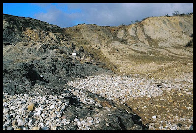
On a visit to Charmouth in March 2012 I went across to the other side of the river with the intention of having a walk part way along the coastal path. As it happened, there was a sign to say that it was closed due to landslides, so I went along the beach instead. I hadn't been along the eastern stretch of the beach before, and it was fascinating to see the results of a landslip whilst it was still fairly new.
I don't know when this particular slide happened, but this length of the World Heritage Jurassic Coast is particularly susceptible to constant upheaval from land slippage and falling cliffs. The most well known landslip occured at Bindon in 1839 along the stretch called The Undercliff between Axmouth and Lyme Regis. Subsequently named The Great Landslip, it became a nationwide fascination for sightseers and geologists alike, the latter learning a great deal from the event.
The cliffs consist of sedimentary rock containing many layers of mud, silt, clay and limestone, which was laid down during the Early Jurassic era. The instability is caused by slopes of Upper Greensand and chalk on top of clay called blockside. Landslips are formed by excessive rainfall lubricating the join between that clay and greensand, enabling the top layers to slide. In the 1839 landslip at Bindon, an entire area of land comprising 15 acres, and weighing an estimated 8 million tons, broke away from the mainland and slid towards the sea, creating an island surrounded by deep chasms...later called Goat Island.
This particular landslip at Charmouth isn't as dramatic as that, but it is quite impressive and it's interesting to see the geology before plantlife grows upon it. It's fascinating to think how natural forces can effect land in this way, and how devastatingly fast the results are after quietly working towards it over a long period of time.
Looking a bit like a building site, my photos really don't do justice to how large it is or the height of the cliffs.
Keep Out - Quick Sand!!!
I expected to see the words 'Danger - Falling Cliffs' on the sign, so it was a surprise to see the words Quick Sand. It does make sense though, as wet limestone chalk has the consistency of porridge and it pulls you in like quick sand. I had an experience of that when exploring a chalk quarry; having to literally dig my feet out of a small heap of wet chalk that I'd sunk into almost up to my knees. That was scary...and not something I'd like to risk repeating.
Another view of the cliffs along from the landslip to Golden Cap, above photo. The one below was taken looking West towards Charmouth.
And I couldn't resist taking a shot of footprints in the sandy earth on the way back over the hill towards the river bridge.
I took quite a few photos while there but they're all pretty much the same. I did take some rather nice ones of the river mouth and beach when I walked back along though, so in the interests of doing my bit for tourism, here they are. :)


No comments:
Post a Comment