Friday, 3 February 2017

Balfour Lodge, Sidmouth, Devon


This delightful Cottage Orne was the former lodge to a large residential house called Knowle Cottage, now called The Knowle which is where the East Devon Council Offices are housed, and is situated at the start of the driveway leading to the main house. Oddly enough, the lodge is now called Balfour Lodge, taking its name from Balfour Manor across the lane behind it. This never was a lodge to the manor house, as the actual lodge is situated at the gateway to the manor drive, and is called South Lodge. Have I confused you yet? ;) Well, just to make things even more confusing, there is another house further up the lane called Knowle Cottage, which is nothing to do with the original one, but I think it may have been a second lodge belonging to it on the north-west of the estate.


A Grade II listed building, Balfour Lodge was built circa early to mid 19th century. Comprising two storeys, with the first floor in the attic, there is a steep pitched hipped roof with gable ends at each side and pretty gabled first floor windows to the front and back. With it's 'crazy paving' finish, and ornate bargeboards, it's a striking and quirky building of the 'gingerbread house' variety.


The Gothic windows are an absolute delight, with cute foliate carvings of ivy, holly and other leaves forming quatrefoil shapes below the hipped and tiled roof of the ground floor oriel window (above).


Above can be seen the projecting stone porch, with tracery patterned bargeboards. Stone quoins surround the door. I'm not sure if that is the original door, as the listed building entry is slightly confusing. Mention is made of a 2-light casement at the entrance front and the door having ornate iron hinges, of which there is now no trace of either...unless the original entrance was at the adjacent side. This may be the case as the house has been converted into two flats. I do love this door however, and the way the window apex echoes the Gothic shape is quite lovely.


The photo above is of the rear, taken from the next lane along; a narrow lane which, oddly enough, is called Broadway, presumably built when it was broader than most roads in the vicinity at the time. ;)

I couldn't help but notice this fab little house whenever I went past on the bus occasionally, but this time I was in a friend's car and as she enjoys mooching around unusual places too, we stopped to get a better look. Which led to us having a meander up Broadway and finding several other places of interest. Great day, with lots of photos to show for it!


Thursday, 2 February 2017

Axminster Railway Station, Axminster, Devon


As the date plaque shows, the station was built in 1859, and was subsequently opened on the 19th of July 1860. The original service offered travel between Queen Street in Exeter to Yeovil in Somerset, with the London and South Western Railway (LSWR). Eventually services were extended to include express trains to Waterloo station in London, and also local services to Exeter St David's and Salisbury.


Typical of the period in this area, it's a beautifully quaint building which has continued pretty much unspoilt. Designed by Sir William Tite in the Victorian Gothic style, it isn't derelict or abandoned, but very much live and used. In fact there have been improvements to the line since these photos were taken during late 2008. The Beeching cuts during the 1960s had earmarked the line for closure, but it was reprieved to having just the one line cut; bringing the two lines down to one. However, recent work has reversed that by opening up the other line to extend the London service to an hourly one, and a new passenger footbridge was built in february 2010, to enable travellers access to the other side.


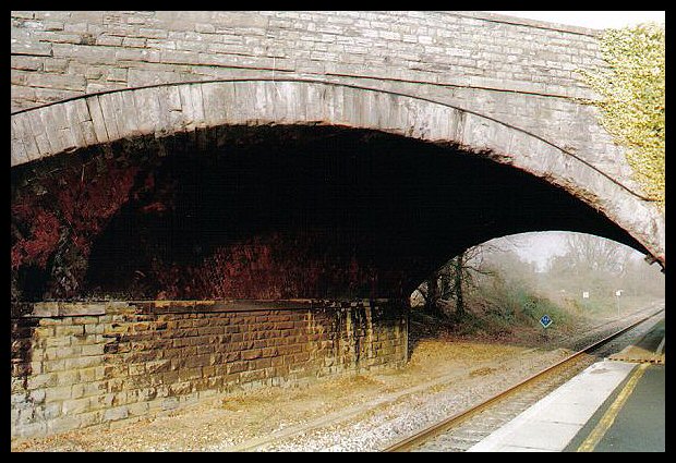
As can be seen in the photo above, one track was in use and the former one had been taken up. The direction shown is the up line for London; the down direction (same line until recently in 2010) to Exeter. The building on the right now houses a delightful little cafe, which was originally a parcel office and staff room.


A close-up of the road bridge, in the photo above. Below, a very rare moment with no people, cars, taxis or buses in front of the station. Mind, I did have to stand there for a good twenty minutes or so to get that photo!


Wonderfully mellow red brick with stone quoins, there was a time in circa 1990 to the early 2000s when the brick was painted over in a very pale magnolia type of colour and the quoins and roof slates were in light grey. I don't recall seeing it like that as I had no occasion to be in Axminster at that time, but having seen a photo of it I can only say that thank goodness it was put back to its original unfaced brick and stone.


A couple of photos of the station side.


And finally, another one of the front.This time with a car in front as I didn't fancy waiting too long for another clear photo! ;)


Farm near Axminster, Devon


A friend living in a mobile home on this farm invited me to visit for a day in 2009. It's a working farm, but a small section has been left unused and allowed to decay. As on all farms, even the well-used parts have that delightful combination of rust, wood, grass and dried mud along with cobbled-together outbuildings. And on this farm, the stunning views of the lovely Blackdown Hills.

 
It was a great opportunity to satisfy my photo cravings, the top photo one of many things which caught my attention. The abandoned cattle feeder (above), on its way to becoming overgrown, creating bold shadows against the corrugated-patched barn, and the barn itself a stark contrast against the bright blue sky.


An unused pigsty, below.


And a delightful cameo of an old watering can standing next to cane fruit growing in a plastic bucket. 


A long-abandoned stone trough above...


...a wonderfully wonky trailer and a few more photos of the buildings...


...and finally the view of the distant Blackdown Hills.


Tuesday, 31 January 2017

Ashley House, Seaton, Devon


Out for a walk with my camera one day, I happened to walk past this lovely old building to see that it was empty with a 'sale agreed' board outside. I wasn't able to ascertain anything about the house itself - the date it was built or any previous history - but I did know that it used to be a care home.


It was a good enough opportunity to wander around and have a look close-up. I didn't intend to take any photos at first - just enjoyed exploring around the back and gardens, which were quite boring to be honest; only a patch of rough grass surrounded by a fence and a few trees - but there are some rather nice features at the front. So, before I knew it, I was clicking away!


The build date was probably around the 1930's due to the mock tudor style, pebble dash and the lovely stained glass leaded panels running along the top of the windows. The downstairs bay windows were also a popular design in housing built between the first and second world wars, when many building projects had begun as part of the 'Homes Fit For Heroes' schemes to provide better housing for those who had fought in the war and their families. This was the first attempt to clear slums and build more spacious housing at a national level. This house was probably out of the price range for many people but it would have made a rather nice home for a middle class or professional family.


A rather bland front porch entrance. The plain glass and the institutional 'no smoking' notice are signs of it's recent occupation. The original windows may well have included stained glass, as was usual with buildings of this style. I loved the light patches on the side wall though.


Above, a rather lovely tiled doorstep with a sweet arrangement of encroaching plants. The photo below shows the balcony above the front porch connecting the two gabled sections of the top floor.


Ivy growing on the side helps to soften some of the pebble dash, which it has in abundance! Although pebble dash was popular when built, it has since become rather passe, and looks quite bland in large areas with the original sandy colour. Having said that, it makes an interesting change in an area where there is none to little of it. I think I'd be very tempted to paint over it in a different colour though! ;) Although it does look nice with the white mock tudor beams at the front.


A garden escapee plant makes a nice image against the grey brick and weathered fencing.


Another image I particularly like is this one below, of an older styled dustbin, overgrown steps and peeled paint on the garden wall. And the photo below that shows more ivy, rampant vallerium and a twiddly-bit (aka curlicues) wrought-iron gate.


Now once again a residential house, it has been redecorated and the front garden landscaped, taking away that institutionalised look of the 'Health & Safety' regulated hand rails. An altogether rather lovely house.


A couple of photos showing the side elevation. 


And finally, a few more photos of the house itself.


WW2 Beach Defences, Charmouth, Dorset


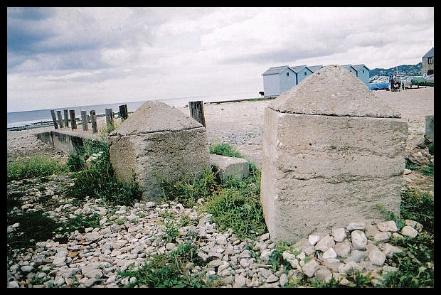
These anti-tank blocks are the remains of extensive coastal defences during WW2. Called Dragon's Teeth, they were linked together with metal poles to form a barrier along the beach. Only these two remain, although there were some forty odd strung along the beach of the river valley.

This was an exciting and unexpected find, as I had no idea they were there until a visit in 2009. The sockets for the poles are still clearly visible and, much to my delight, give them cute and comical faces!


I only took four photos at the time (including the two above and one below) but have added more from a later visit in July 2011, when a walk along the river from the bridge towards the blocks revealed some more interesting bits and pieces.


A concrete edge and some hard standing beneath the later car park tarmac, below, may have nothing to do with WW2. However, a short walk further on revealed something rather interesting.


Metal poles fixed at angles into concrete bases, holding bales of barbed wire in the cross pieces, were often used for beach defences, and this lump of concrete embedded with pieces of rusted metal could possibly be one of the remains. These are on the town side, therefore it makes sense that it would be defended from attack along the river.


Some small concrete blocks with rusty links embedded in the top have been put near the anti-tank blocks since my last visit.


The cliff in the background is called Cain's Folly. During WW2 there was a radar station situated there, but unfortunately it was built too near to the cliff edge and during May 1942 a landslip occured, sending a building plus three lorries 50 ft below. The generator house slid down later.


Another small block, below, and a drain cover...which has nothing to do with anything, but it looks quite old and I rather like it. ;)


Finally, another view from my very first visit, with a row of funky huts in the background which are now on the sea front.