Monday, 26 June 2017

The Lyme Round House, Flax Drying/Wool Drying Tower, Lyme Regis, Dorset


I first noticed this whilst on a visit with some friends during early 2009. We speculated on what its original use was and when I returned home I tried to find out online, without success. It wasn't until later that I saw it labelled as a Flax Drying Tower on a delightfully illustrated tourist map that I'd picked up from a shop, yet still unable to find any other information.

Fast forward to June 2011, when a visit to Lyme brought me near to the tower again, and when I took these photos. Still unable to find anything about this particular building but further searches provided rather a lot of background information about the flax industry in the area.


The beautiful blue-flowered Flax plant has many properties. As well as the production of linen, the oil from its seeds have been used for oil cake - a cattle feed - and for Linseed which is used to make paint, putty and varnish. However, it is assumed that flax was grown locally for small-scale production of linen or twine. Loom House, near Cannington Viaduct in Uplyme, was found to have flax in the attic. Both flax and hemp was known to have been grown in West Dorset for twine and cordage during the late 18th and 19th centuries.

Another local need was that of sailcloth, ropes and netting for boatbuilding and fishing. Twine and cordage produced from flax is indicated by the names of fields in the area, such as Spinning Yard and Line Walk, which refers to long, narrow and open walkways lined with trees to afford shade and support for holding the yarns off the ground.

After researching the flax industry in the area, I still had no idea about this particular building. However, another fast forward to December 2013, when I received an email from a gentleman who was researching a tower in Ireland. After a few emails back and forth, and further research, I found that it's called The Lyme Round House and was probably a wool drying tower.

Apparently, wool was quite an extensive production in the Lim Valley, involving families, farms, watermills and, later on, two small factories alongside the River Lim; the various processes contributed by the people of Lyme Regis and Uplyme just over the border in Devon. However, there still remains an historical link to flax, therefore I'm hedging my bets by keeping both wool and flax in the title. ;)


I apologise for the lack of photos but this was the nearest I could get to it as it's situated on private ground. There may be another vantage point from the other side but I wasn't sure how to get there and I didn't have enough time to investigate on that day. One that I meant to try again another day! 


Emergency Forest Phone, Couchill Woods, Seaton, Devon


I found this several years ago, on the edge of Couchill Woods, and haven't been able to ascertain what it actually is. I think it's some sort of utilities box as there is evidence of wiring. The woods are managed by the Forestry Commission, and because it needs a specific key to open it may have been for the use of forestry workers only. Electrical point maybe? However, on doing some research and having forum discussions with like-minded souls, we thought it may be an old emergency phone in case of accidents.


I recently did some more research but still couldn't find any concrete evidence of what it was, or any pictures which show anything the same or similar. I sent an email to the Forestry Commission asking if anyone knows, along with a photo. After kindly asking around, they were unfortunately just as stumped as me.


Of course, with the widespread use of mobile phones there wouldn't be much need for a standing phone, which would make sense as to why it was abandoned. So, until I'm told otherwise, I'll just keep calling it an Emergency Forest Phone.

Whatever it is, or was, I think it's really fab. Lovely woods, green peely paint and rusty goodness. What more could a girl want?


Tuesday, 20 June 2017

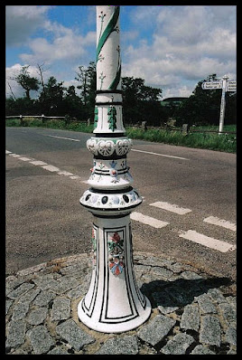
Decorated Lamposts, Colyton, Devon


Named "the most photographed lampost in Devon", this beautifully painted, ornamental lampost is situated on a small roundabout near the Umbourne bridge at the eastern end of Colyton, and is an absolute delight. An unusually ornate Victorian cast iron post, the decoration includes a coat of arms on the base and a garland around the stem.


Some of the other details can be seen in the above photo, painstakingly painted in colour against a white background. Apparently, there were several similar lamposts in and around the city of Exeter, but sadly they were sold off to private purchasers when new roads were built or old ones widened or redirected, and new, modern lamposts were installed. I believe a few of the decorated ones found their way into private gardens.


The other lampost, below, began life as a drinking fountain. So, it isn't exactly in the same category as the decorated ones, but I felt it definitely deserved a look and a mention. Taken at a different time, I used some old Kodak stock film that a friend had given me for the drinking fountain, which produced a rather pastelly look with a blue overcast. I always meant to go back and take some more but never managed to get around to it. Story of my life, lol.


Erected on March the 10th, 1863, with the surplus of funds collected to commemorate the wedding of the then Prince of Wales, the inscription reads...


"March 10 1863 has been devoted to the erection of this fountain by the patriotic protestants of Colyton, as a permanent memorial of that national triumph and vindication of their own loyalty by vote of committee".


Interestingly, during the Monmouth rebellion of 1664, Colyton earned an entry in Chancery records as "the most rebellious town in Devon". As they had sided with the protestants we can see why they were keen to show their loyalty to the Crown and be forgiven for their rebellion.


Manufactured by Garton & King, Iron Founders of Exeter, who can trace their trading history back to 1661. They have a fab website including their well documented history, which I've added the link to below.
 

http://www.exeterfoundry.org.uk/


And two more views of the first painted lamp post, showing its somewhat precarious position at the junction, where - if memory serves - it's been accidentally driven into on more than one occasion!  


Exe Bridge & Chapel, Exeter, Devon


This Mediaeval bridge and chapel has got to be the coolest traffic island ever!

 
During the 1960s and 70s the road system was altered in order to include a ring road around the west side of the city centre (known as the West Quarter). The ancient street between the bridge and the hitherto site of West Gate was excavated and several houses were demolished, during which the remains of the eastern end of the bridge was discovered. Originally consisting of 18 arches, only these 8 remain. The River Exe is a lot less wider than it was then, due to the making of leats in order to reclaim marshy land for building purposes, therefore these remains are no longer across the river but are left stranded in the centre of this busy road system.


The first of five bridges across the River Exe, this one was built by Nicholas Gervaise and his son Walter, and was completed in 1238. It originally supported two chapels; St Edmund's Chapel at the eastern end, of which only the tower remains, and St Thomas's at the western. There were also houses on the bridge, built as an income for maintaining the structure, but nothing remains of them or St Thomas's Chapel now. It is thought that there may have been an earlier Roman bridge, but there are no remains or documentation to corroborate it. However, a wooden bridge had been previously constructed for pedestrains, whereas a ford was used for carts and herding livestock across.

 
The inclusion of St Edmund's on the bridge replaced an earlier chapel, and this too was rebuilt in 1834 after being burnt down in 1832. Most of the original tower remained and the rest of the church was rebuilt using material from the old building. 


Mostly constructed with the red volcanic rock known as 'trap', which was quarried from Northernhay near Rougemont Castle, it is now the oldest surviving mediaeval stone bridge in England.


A few remains of the Victorian church can be seen around the base of the tower, including the capped well below.


And finally, inside the tower with two of the resident pigeons.


Visited in April 2009, my photos aren't exactly the best in the world! The colours are a bit odd, which I think was due to the light that day - one of those Spring days when foliage takes on a lime hue and buildings look somewhat pink - and which is why I edited some of them to black & white. Using a 35mm camera, film picks up the actual colours that we don't always notice with our own eyes, and you can't see what you've got until the films are processed, so it's long overdue for a return visit to take more photos. I think I'll leave it until Autumn next time though, just to make sure. ;)


Friday, 16 June 2017

Drinking Fountain & Horse Trough, Sidmouth, Devon


This was an unexpected and lovely surprise to find this horse trough and drinking fountain next to each other. Unfortunately, I haven't been able to discover anything about them, apart from one photo in which the wall appeared to have been newly built. Which begs several questions...were they moved from elsewhere and built into this wall, were they already here but the wall needed replacing or repairing, or are they modern replicas built into the wall for decoration?


They don't appear to be on the British Listed Buildings list, but I have recently discovered that not all listed buildings are. Also, many buildings, or architectural details of interest, aren't necessarily given listed status because they don't have the specific requirements needed. Some that have since become eligible for listing have not been applied for, or have been exempted from application by the Council. All of which makes sense, as there are quite a lot of lovely old buildings and other curiosities in Sidmouth that don't seem to have a listed grade.


The drinking fountain is cast iron, beautifully decorated with flowers, foliage and curlicues; in the central motif what I think appears to be a stork standing on a shield, and a dragon reclining at each end of the headpiece. I couldn't see a date, or any other written information, and scarcely had time to do anything other than take the photo as, contrary to the look of an empty road, it really was quite busy on that corner and a little too dangerous to stand where the pavement had petered out to just road. From my photo it looks as though the water trough was cast iron too, but I didn't get near enough to peruse it properly.


So, all in all, a bit of a conundrum. I've only got these four photos, but when I'm up that way again I'll try to get some more and add them to this article. I'll also add any further information if I come across it. :)


Dowlands, Devon


A tiny hamlet between Axmouth and Rousdon in East Devon, it consists of Dowlands House, Dowlands farm and two or three residential houses and / or holiday cottages.


Dowlands House is a Grade II listed building. Built in 1847 with a date plaque above the front entrance, it is a stone house with ashlar front consisting of two storeys plus an attic.  There is a gabled cross-wing on the right side and a slate roof covering both, with stone coping at the gable ends, rendered ridge and end chimney stacks.

A gabled stone porch with four centred arch doorway, along with stone mullioned windows in the Tudor Style, gives it the apprearance of a much older building. I puzzled over the date until further research reminded me of the reason why that might be...


On Christmas Eve 1839, the great landslip below Dowlands and Bindon occurred, creating a huge chasm. The farmhouse at the time was untouched, but as the new house was built some eight years later, it is possible that the original structure may have been weakened. What is interesting is that a visitor to my website kindly sent an email to tell me that the gabled cross-wing on the right hand side is the oldest part of the building, and that the frontage to the left was the later part built in 1847. It was also renovated inside in 1987.


One delightful story is that the tenant farmer of the original farm, Mr Chappell, began to charge visitors sixpence each to use the old cart road on his land to reach the natural tourist attraction, after much of his crops had been trampled on by earlier sightseers. It took a little while for the farmers and other locals to catch on, but pretty soon places were open for the sale of tea & snacks, and overnight stays, creating the start of the tourist industry in the area.


According to its listed building status, Dowlands House was the original farmhouse, therefore any other buildings which existed at the time were all part of the farm too. The building to the left of the House has a sign saying Dowlands Farm and may have been originally either a farm building, cottages for farm workers or tenants, or it may have been built later. However, the road side gable shows that later windows have replaced earlier ones and that there was once a small gable above the top storey one.


A small walled garden to the front of the house and some grass verges between the buildings and the lane, edged with stone boundaries - which I'm guessing is to prevent people from parking their cars there. Altogether a delightful little hamlet. :)