Sunday, 7 May 2017

Colmer's Hill, Symondsbury, Dorset


According to the Charter of Cerne Abbey in 987, this area was known by the name of Aeschere, but the hill was later named Sigismund's Berg by the Viking chief Sigismund, when he saw the beacon on the hill's summit.  The name Symondsbury is a corruption of the earlier Sigismund's Berg (Berg being Norwegian for Hill), which is now the name of the nearby village. The name Colmer's was given to the hill much later in the 19th century; named after the Reverend John Colmer, who was the landowner and local rector of Symondsbury from 1805-06. The trees on the summit were planted during the first world war.

These photos were taken from Quarr Lane, which is situated on the opposite side of the hill to the village. As the name suggests, there was once a quarry nearby.


An iconic Dorset hill, it's very prominent for miles around. It has the look of a tumulus, but I haven't come across anything to suggest that, and it isn't marked as one on the OS map. However, I wouldn't be at all surprised, as you can't walk very far in West Dorset without tripping over one!


Near to the top of Quarr lane, the sun obliged by lighting up the gorgeous coppery colour of the Autumnal bracken which covers the hillside.  Even when the sun's behind cloud it's still a stunning sight!

Colmers hill cannot be seen halfway along Quarr Lane, but it was still a lovely view on this late October day.


I only managed to take these four photos as it was a quick stop while in a visiting friend's car. The plan was to revisit at some point and take photos from the other side, and explore the area further, but that's easier said than done as I don't drive and it's not easy to get to on public transport. A little bribery of another friend might be attempted! ;)


The Cobb, Lyme Regis, Dorset


Mentioned in the 1086 Domesday Book, Lyme developed into a major port by the 13th century. The addition of Regis to the town name was due to Royal Charter granted by King Edward in 1284, and was later confirmed by Queen Elizabeth I in 1591. The development of Lyme as a major port and shipbuilding centre was mainly because the artificial harbour, known as the Cobb, acts as a protection from storms.


Existing since at least 1313, the earliest construction consisted of an infilling of large boulders held in place by oak piles driven into the sea bed, in a basic shape similar to how it is now. The Cobb at that time was not connected to the mainland however, and it wasn't until 1756 that a causeway was built. The present walls date from 1824, when it was rebuilt after being breached by storms.


In the photo above, the 'Gin Shop' can just about be seen
set into the wall with steps either side at the point where the wall curves to the left. Don't get too excited though, as it doesn't sell alcohol drinks but is a former ammunition store holding the ball and powder for the cannon which were used to defend the Cobb. Its name derives from the hoist lift which was once set above the store. Sorry to disappoint! ;)


There was at one time a cement factory further west along the beach, and the old wooden posts set into the sand in this corner of the harbour are the remains of a horse-drawn truck railway that ran between the two, presumably for loading on and off the ships.


The High Wall continues out into the bay behind the central Cobb buildings. The wall once extended further out but was lost during the severe storms and was never rebuilt. However, the foundations can still be seen at low tide.


The buildings date from around 1723 and have variously been used as a warehouse, an isolation hospital and a yacht club. They are now used partly for fishermens stores and the Marine Aquarium.


Two wonderful connections with the Cobb involve literary characters by the well known authors Jane Austen and John Fowles. Jane Austen visited Lyme and set part of her book 'Persuasion' here, taking many local names for the names of her characters. One of her heroines, Louisa Musgrove, insisted on being 'jumped down' from the Cobb steps by one of the heroes. Wanting a second 'go', she ran back up the steps and jumped before he was ready, falling badly in the process, whereupon she was 'taken up lifeless' to a nearby house to recover.


John Fowles's character was the melancholic and enigmatic Sarah Woodruff from 'The French Lieutenant's Woman', who often stood at the end of the Cobb staring out to sea, supposedly mourning the loss of her French lover who left and disgraced her. The film of the same name was set in Lyme and the Cobb was used as well as the Undercliff which runs between Lyme Regis and Axmouth in Devon.
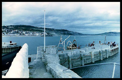
 

There is so much history attached to the Cobb, that I've only put in the few snippets that I find personally interesting. The photos were taken at various times. The b&w photos were taken circa 1991, when I was braver then than now, and I was able to walk along the wall.  The blue ones were taken in 2009. The prints came out garish and almost unscannable, but when I obtained a neg scanner I found that the negatives were mostly cyan and that the printer had added the colours during the printing stage. I stopped using that printer afterwards, although I must admit I love the effect of these particular photos. And the final views of the Cobb from the gardens were taken in early 2011. 


Outside the Marine Aquarium sits this wonderful piece of driftwood upon a crab pot. Queue the music to the film 'Jaws'...
 
Finally, the overall view below. I'll see if I can explain it.

On the right the Cobb swerves out from the mainland. The High Wall is carried on the right side of that and continues in a lazy S shape out into the bay, affording wonderful views for those who wish to tread the footsteps of the 'French Lieutenant's Woman'. The central piece contains buildings which now hosts the Marine Aquarium, the left arm of which is the Victoria Pier used by fishing boats and anglers. The left side is the North Wall with a gap between the sea end and the rest of the Cobb (called Crab Head), enabling boats to navigate in and out of the harbour.

Lyme Regis is such a fabulous little town with lots of interesting buildings and loads of history. Well worth a visit if possible. :)


Thursday, 20 April 2017

WW2 Coastal Defences, Seaton, Devon


All coastal towns during the second world war had defences put in place in the event of an invasion. As well as the Coastal Battery at Axmouth Harbour, which was at the start of an inland line of defensive emplacements called the Taunton Stop Line, other defence remains can be seen in Seaton along the seafront. This area was an important position because German aircraft used the Axe Valley as a flight path from France up to Bristol and the West Midlands. The Taunton Stop Line was particularly important because of the munitions base situated near Taunton, which had to be defended from land invasion as well as from the air.


A hexagonal plinth upon concrete hard standing (above) marks the place on the western cliffs where an emergency Royal Artillery Coastal Battery stood. It was camouflaged beneath a wooden construction to look like a house. Interestingly, the only bombing of Seaton occurred was of Jubilee House (now Jubilee Gardens) when a German bomber jettisoned unused shells prior to the flight back across the channel.


Further eastwards along the path I found what looks like the opening to an underground bunker. It may have been a shelter, but I think (and please don't quote me on this) that it may have been an underground armament store. My reasoning is because of its situation; near enough to supply the battery, but far enough to be out of the line of fire. It is also similar to other WW2 MOD constructions, and thin lead lining can just about be seen between the brickwork and concrete.
 

On the road east to the clifftop is this variant pillbox. Hardly recognisable, unless you know that it's there, it has since been converted into the end part of a roofed parking area for Cliff Castle House behind.


The embrasures have been infilled with the same kind of building material of flint and chert, but can just about be made out beneath the concrete lintels in the photos below.


Below the pillbox, and built into the cliff under the road, is a Coastal Artillery Search Light Emplacement. This would have housed a very powerful lamp to sweep the sea and beach for enemy craft in the event of a land invasion by sea.


The photos were taken at various different times. The emplacement was once open and accessible - hence the graffiti - but a metal grille door has now been added after the building was given a fresh coat of paint. Sadly, there's still the odd thoughtless person clambering in to make their mark.


It isn't until getting inside that you realise what an amazing view can be seen of the sea and coastal area.


At one time, many years ago, there were removable shutters to the front opening. A visitor to my erstwhile website kindly told me that it was used by Seaton beach lifeguards in the 1970s, which I vaguely remember, and which was a very appropriate use for such a fantastic view.


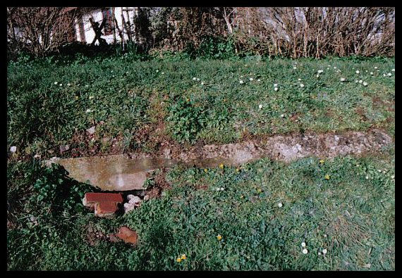
These remains (below) can be seen at low tide during the spring tides. I haven't been able to ascertain for certain whether they were parts of the WW2 beach defences or just old remains of eroded steps. However, on beaches during the war scaffolding pipes were fixed into concrete bases, the crosspieces of which were filled with bales of barbed wire...and these look as if they may have been used for that purpose.


And finally, a couple of photos of the Searchlight Emplacement with its newly decorated look and new information board attached. A particularly big thank you to all those who have worked for many years to obtain the info board, of which I had the pleasure to be asked to add one of my photos from this article.


And here it is close up with my name on the credits at the bottom.
 

For more information about the Taunton Stop Line and photos of the pillboxes along the Axe Valley, please see the blog post Axe Valley WW2 Defences - Taunton Stopline Part One, which can be accessed here.


Cliff Castle and St Elmo, Seaton, Devon


This Grade II listed building was built in the mid 19th century; its wonderfully Victorian Gothic style - and elevated position overlooking the bay - suggesting wealth and fashionable eccentricity.

Comprising three storeys, and a Mansard attic storey, the corners and front bays are flanked by round turrets with fake cruciform arrow loops and topped with machicolations. I had to look that last word up! It means openings by which missiles could be dropped from a parapet onto the enemy below...those rampaging hoards of Victorian peasants! ;)


The building comprises two houses, and was probably originally built as two rather than one huge dwelling. Interestingly, this was a time when our own seaside towns were becoming popular as holiday destinations due to the political situation with France. Instead of touring Europe, people with means were looking to our own shores on which to throw up Cottage Orne and other delightfully neo-rustic buildings in which to stay for the summer months. This may even have been an early property venture as lettings to entice the wealthier classes to stay and spend locally.


Now converted into flats, there are modern windows in the balcony recess of Cliff Castle, with modern bay windows to the left. The later addition of a Mansard roof houses an attic storey penthouse. St Elmo on the right, above, retains a lovely arcaded second floor. The windows consist of delighful intersecting glazing tracery, and are surrounded by projecting arches.


One source (The Book of Seaton by Ted Gosling) suggests that it was built in 1825 by the local banker and builder Joseph Good. Originally used as his own residence it was later sold, at which time he added the crenelations at the behest of the new owner. He also donated part of the land to make the new Castle Hill road, which connects with the route to Beer village.

Joseph is also credited with building Calverly Lodge and Seaforth Lodge, but as these were commissioned by Sir Walter Trevelyan and Lady Ashburton respectively and designed by well-known architects, I should imagine that the term builder in his case refers to owning a building company contracted for building construction.


Situated on a sharp corner of Castle Hill, the photos above and below show the side elevation, along with Cliff Cottage tacked at the rear. 


And finally here's a view of the buildings from further down Castle Hill. The rounded wall is interesting because the flint & rubble end was originally a WW2 defence Type 24 Variant pillbox. The embrasures have been infilled, although close-up the outlines can still be seen, and it was built upon to give it more height. A wall has been tacked on to the right of it and a roof added to provide a covered parking bay.


More about the pillbox in the next post featuring Seaton's beach defences during WW2, the remains of which can still be seen. And the little thatched building to the left of the hill in the above photo will also be coming up in a future post. :)


Oldbury Castle Hillfort, Cherhill, Wiltshire


I wasn't going to post up this visit, as I only have these four photos - and not very good ones at that - but having recently came across some interesting history about it I decided to include it after all. I've enlarged them for this article so that the details are a little clearer. Situated near to the village of Cherhill, on the route between Calne and Marlborough, it was a quick stop on the way to Avebury, Stonehenge and other prehistoric sites which I visited in 2008.

What's interesting about the site is that it comprises a large earthwork, known as Oldbury Castle or Camp, the Cherhill White Horse, and an obelisk known as the Lansdowne Monument. The horse can just about be seen in the above photo, situated below the right side of the stand of trees.


An Iron Age hill fort, it covers 22 acres and includes a long barrow, with several other barrows within the nearby downland. Sitting upon an earlier Bronze Age settlement, finds include Bronze Age tools and also evidence of Roman occupation. In Cherhill village itself, the remains of a tessellated pavement featuring images of a hunting dog was uncovered near the church...possibly part of a Roman Villa. Like much of Wiltshire, the area is teeming with prehistoric remains, including prehistoric field systems on Cherhill Down connecting with the border to Avebury.


Eight still remain out of the original thirteen chalk Wiltshire horses; Cherhill being the second oldest. Cut in 1780 by Dr Christopher Alsop of Caine, it had the unusual feature of a glass eye formed by pressing upturned bottles into the ground, thereby reflecting the sunlight. They had all disappeared by the late 19th century however, and were replaced in the early 1970s during a local youth centre project. The youngsters put their names inside the bottles before setting them in the ground, but sadly they too eventually disappeared and the eye is now made from stone set into concrete.

The Lansdowne Monument was erected in 1845 by the Third Marquis of Lansdowne, and is a striking 125 ft stone obelisk that can clearly be seen for miles around. Consisting of three high steps, pedestal and main shaft, the base of the monument has now been fenced off with nets to catch stonework which has eroded due to recent cold winters.


Just a short post for this visit. I don't know how easy it is to access the earthwork but this was the closest I could get on a brief stop to have a look at it. However, for anyone in the vicinity with some more time, it might be worth a more thorough explore. :)